
Fiumicino and Its History
The Municipality of Fiumicino was established in 1992, gaining administrative autonomy following a referendum that allowed it to separate from Rome (Regional Law No. 25, March 6, 1992). It has an average altitude of 1 meter above sea level and, with its 213.89 km² of surface area, is the 5th largest municipality in Lazio by territorial extension.
The municipality is divided into 14 localities: Aranova, Fiumicino town, Focene, Fregene, Isola Sacra, Maccarese, Palidoro, Passoscuro, Parco Leonardo, Testa di Lepre, Torrimpietra, Tragliata, Tragliatella, and Vignole. In addition, the area encompassing the entire Fiumicino Leonardo Da Vinci International Airport is also included.
Localities
Fiumicino Town: Developed around the port-canal, the town was designed in the early 1800s by architect Giuseppe Valadier. Built with materials recovered from the ancient city of Porto, the town included a church, a customs house, a post office, a hotel, many inns, and a row of residential buildings separated from the canal by Italian-style gardens. The land reclamation efforts, its natural vocation as a port of call, and the establishment of the intercontinental Leonardo Da Vinci airport in the 1950s and 60s contributed to its growth in both area and population. Unfortunately, the construction boom of the 1950s and subsequent illegal building practices radically altered the landscape.
Isola Sacra: Home to about 14,500 inhabitants, this district occupies roughly two-thirds of the eponymous island near the Tiber River. It was established in the 1930s following the “Reclamation of Isola Sacra.”
Focene: A coastal village with approximately 3,500 residents, Focene was originally a fishing settlement established in the 1940s. The area grew in the 1960s with the construction of the Fiumicino airport, and during the same period, it became a popular summer residence for notable figures and families, such as the Sciascia and Colonna families. The Torlonia family also had an estate within the “Pineta” (Mediterranea pine forest) near Focene’s southern entrance, which now belongs to the Cesarini-Sforza family.
Le Vignole: Located in the Roman countryside, this area has recently undergone rapid development and valorization, with real estate projects and the construction of a large shopping center.
Parco Leonardo: A pedestrian-only development where vehicles can only circulate around the perimeter and underground levels. The neighborhood was designed in 1993 based on a master plan by Catalan architect Ricardo Bofill. The goal was to create a “city within a city” – a self-contained residential area designed with modern and innovative criteria.
Tragliatella: The northernmost locality of the Municipality, Tragliatella is a small agricultural village with around 700 inhabitants. It was established in 1953 by the Ente Maremma, which constructed a small cluster of houses and services for its employees. Close to the village are natural caves that were further excavated during the Etrusco-Roman period. Not far from here, the Torre del Pascolaro stands, an ancient outpost for the nearby Castle of Tragliata.
Tragliata: Located at the gates of Rome, on a striking tuff spur, Tragliata has Etruscan origins. Among the buildings from different periods, the castle stands out. Built between the 9th and 10th centuries, it originally served as a defensive and watchtower structure before being later transformed into a large farmhouse for residential and agricultural use. The hillsides are dotted with typical caves, used throughout the centuries as storage or animal shelters. Currently, the entire village is privately owned and has been converted into an agritourism business.
Testa di Lepre: This agricultural center, with around 750 inhabitants, dates back to the medieval period and was originally known as Testaleporis. Over the centuries, it was a feudal possession of several noble families, including the Normans, Anguillara, and Cenci families, before passing to the Doria Pamphilj heirs. In the 1950s, the Ente Maremma acquired land in the area and developed it into an agro-industrial center with additional services, creating a modern village.
Torrimpietra: Stretching along the Via Aurelia, Torrimpietra has more than 3,100 inhabitants. The name derives from “Torre In Pietra,” a 12th-century castle. The fortified village was inherited by various Roman noble families over the centuries. In the late 1920s, after a long period of neglect, Senator Luigi Albertini restored the castle and reclaimed the surrounding land, establishing a large agricultural business that has since been divided among his heirs.
Palidoro: This locality, home to approximately 1,750 residents, lies near km 30 of the Via Aurelia, immersed in a stunning rural landscape. The name comes from the Latin “paritorium” (ruin) and is associated with Roman ruins upon which a 15th-century castle was built. In the 16th century, the property was sold to Camilla Peretti (sister of Pope Sixtus V), and by the end of the century, it was transferred to the Arcispedale di Santo Spirito in Saxia, which transformed the original fortification into a thriving agricultural business. The medieval Tower of Palidoro stands at the mouth of the Palidoro stream, where Carabiniere Salvo D’Acquisto was executed by the Nazis in 1943; a monument commemorating him stands within the village.
Passoscuro: This locality, with over 4,400 inhabitants, has been frequented since Roman times. The first modern settlement consisted of huts built by clamshell fishermen from Minturno. In the 1950s, a small group of houses emerged, and the area began to attract hunters, shepherds, and a few beachgoers. Today, Passoscuro is a coastal village with small, low houses and a strong focus on beach tourism.
Aranova: Until the early 1950s, Aranova was a large agricultural estate stretching from the Via Aurelia to the hills in the northeast. The estate was sold for agricultural use, and by the 1960s, the area saw significant urban development, bringing the population to around 6,000.
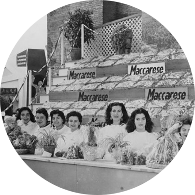
Maccarese: An agricultural locality with nearly 5,000 residents, Maccarese is the result of the comprehensive land reclamation efforts of the 1930s. The area has retained much of its rural character, with characteristic red-colored settlements scattered throughout the landscape. On the right bank of the Arrone River stands the Castle of San Giorgio, whose origins date back to the 13th century. Over the years, the castle and surrounding estate passed through the hands of numerous Roman noble families, eventually coming into the possession of the Rospigliosi family in the 18th century. The castle and its vast agricultural estate are now privately owned.
Fregene: With 6,700 inhabitants, Fregene is one of the most populous localities in the municipality. A prominent seaside destination, it saw significant urbanization starting in the 1960s. The town is still a popular tourist destination due to its Monumental Pine Forest, dating back to 1666, and the charming Fishermen’s Village, which adds to its appeal.


Fiumicino and Its History
The Municipality of Fiumicino was established in 1992, gaining administrative autonomy following a referendum that allowed it to separate from Rome (Regional Law No. 25, March 6, 1992). It has an average altitude of 1 meter above sea level and, with its 213.89 km² of surface area, is the 5th largest municipality in Lazio by territorial extension.
The municipality is divided into 14 localities: Aranova, Fiumicino town, Focene, Fregene, Isola Sacra, Maccarese, Palidoro, Passoscuro, Parco Leonardo, Testa di Lepre, Torrimpietra, Tragliata, Tragliatella, and Vignole. In addition, the area encompassing the entire Fiumicino Leonardo Da Vinci International Airport is also included.
Localities
Fiumicino Town: Developed around the port-canal, the town was designed in the early 1800s by architect Giuseppe Valadier. Built with materials recovered from the ancient city of Porto, the town included a church, a customs house, a post office, a hotel, many inns, and a row of residential buildings separated from the canal by Italian-style gardens. The land reclamation efforts, its natural vocation as a port of call, and the establishment of the intercontinental Leonardo Da Vinci airport in the 1950s and 60s contributed to its growth in both area and population. Unfortunately, the construction boom of the 1950s and subsequent illegal building practices radically altered the landscape.
Isola Sacra: Home to about 14,500 inhabitants, this district occupies roughly two-thirds of the eponymous island near the Tiber River. It was established in the 1930s following the “Reclamation of Isola Sacra.”
Focene: A coastal village with approximately 3,500 residents, Focene was originally a fishing settlement established in the 1940s. The area grew in the 1960s with the construction of the Fiumicino airport, and during the same period, it became a popular summer residence for notable figures and families, such as the Sciascia and Colonna families. The Torlonia family also had an estate within the “Pineta” (Mediterranea pine forest) near Focene’s southern entrance, which now belongs to the Cesarini-Sforza family.
Le Vignole: Located in the Roman countryside, this area has recently undergone rapid development and valorization, with real estate projects and the construction of a large shopping center.
Parco Leonardo: A pedestrian-only development where vehicles can only circulate around the perimeter and underground levels. The neighborhood was designed in 1993 based on a master plan by Catalan architect Ricardo Bofill. The goal was to create a “city within a city” – a self-contained residential area designed with modern and innovative criteria.
Tragliatella: The northernmost locality of the Municipality, Tragliatella is a small agricultural village with around 700 inhabitants. It was established in 1953 by the Ente Maremma, which constructed a small cluster of houses and services for its employees. Close to the village are natural caves that were further excavated during the Etrusco-Roman period. Not far from here, the Torre del Pascolaro stands, an ancient outpost for the nearby Castle of Tragliata.
Tragliata: Located at the gates of Rome, on a striking tuff spur, Tragliata has Etruscan origins. Among the buildings from different periods, the castle stands out. Built between the 9th and 10th centuries, it originally served as a defensive and watchtower structure before being later transformed into a large farmhouse for residential and agricultural use. The hillsides are dotted with typical caves, used throughout the centuries as storage or animal shelters. Currently, the entire village is privately owned and has been converted into an agritourism business.
Testa di Lepre: This agricultural center, with around 750 inhabitants, dates back to the medieval period and was originally known as Testaleporis. Over the centuries, it was a feudal possession of several noble families, including the Normans, Anguillara, and Cenci families, before passing to the Doria Pamphilj heirs. In the 1950s, the Ente Maremma acquired land in the area and developed it into an agro-industrial center with additional services, creating a modern village.
Torrimpietra: Stretching along the Via Aurelia, Torrimpietra has more than 3,100 inhabitants. The name derives from “Torre In Pietra,” a 12th-century castle. The fortified village was inherited by various Roman noble families over the centuries. In the late 1920s, after a long period of neglect, Senator Luigi Albertini restored the castle and reclaimed the surrounding land, establishing a large agricultural business that has since been divided among his heirs.
Palidoro: This locality, home to approximately 1,750 residents, lies near km 30 of the Via Aurelia, immersed in a stunning rural landscape. The name comes from the Latin “paritorium” (ruin) and is associated with Roman ruins upon which a 15th-century castle was built. In the 16th century, the property was sold to Camilla Peretti (sister of Pope Sixtus V), and by the end of the century, it was transferred to the Arcispedale di Santo Spirito in Saxia, which transformed the original fortification into a thriving agricultural business. The medieval Tower of Palidoro stands at the mouth of the Palidoro stream, where Carabiniere Salvo D’Acquisto was executed by the Nazis in 1943; a monument commemorating him stands within the village.
Passoscuro: This locality, with over 4,400 inhabitants, has been frequented since Roman times. The first modern settlement consisted of huts built by clamshell fishermen from Minturno. In the 1950s, a small group of houses emerged, and the area began to attract hunters, shepherds, and a few beachgoers. Today, Passoscuro is a coastal village with small, low houses and a strong focus on beach tourism.
Aranova: Until the early 1950s, Aranova was a large agricultural estate stretching from the Via Aurelia to the hills in the northeast. The estate was sold for agricultural use, and by the 1960s, the area saw significant urban development, bringing the population to around 6,000.
Maccarese: An agricultural locality with nearly 5,000 residents, Maccarese is the result of the comprehensive land reclamation efforts of the 1930s. The area has retained much of its rural character, with characteristic red-colored settlements scattered throughout the landscape. On the right bank of the Arrone River stands the Castle of San Giorgio, whose origins date back to the 13th century. Over the years, the castle and surrounding estate passed through the hands of numerous Roman noble families, eventually coming into the possession of the Rospigliosi family in the 18th century. The castle and its vast agricultural estate are now privately owned.
Fregene: With 6,700 inhabitants, Fregene is one of the most populous localities in the municipality. A prominent seaside destination, it saw significant urbanization starting in the 1960s. The town is still a popular tourist destination due to its Monumental Pine Forest, dating back to 1666, and the charming Fishermen’s Village, which adds to its appeal.